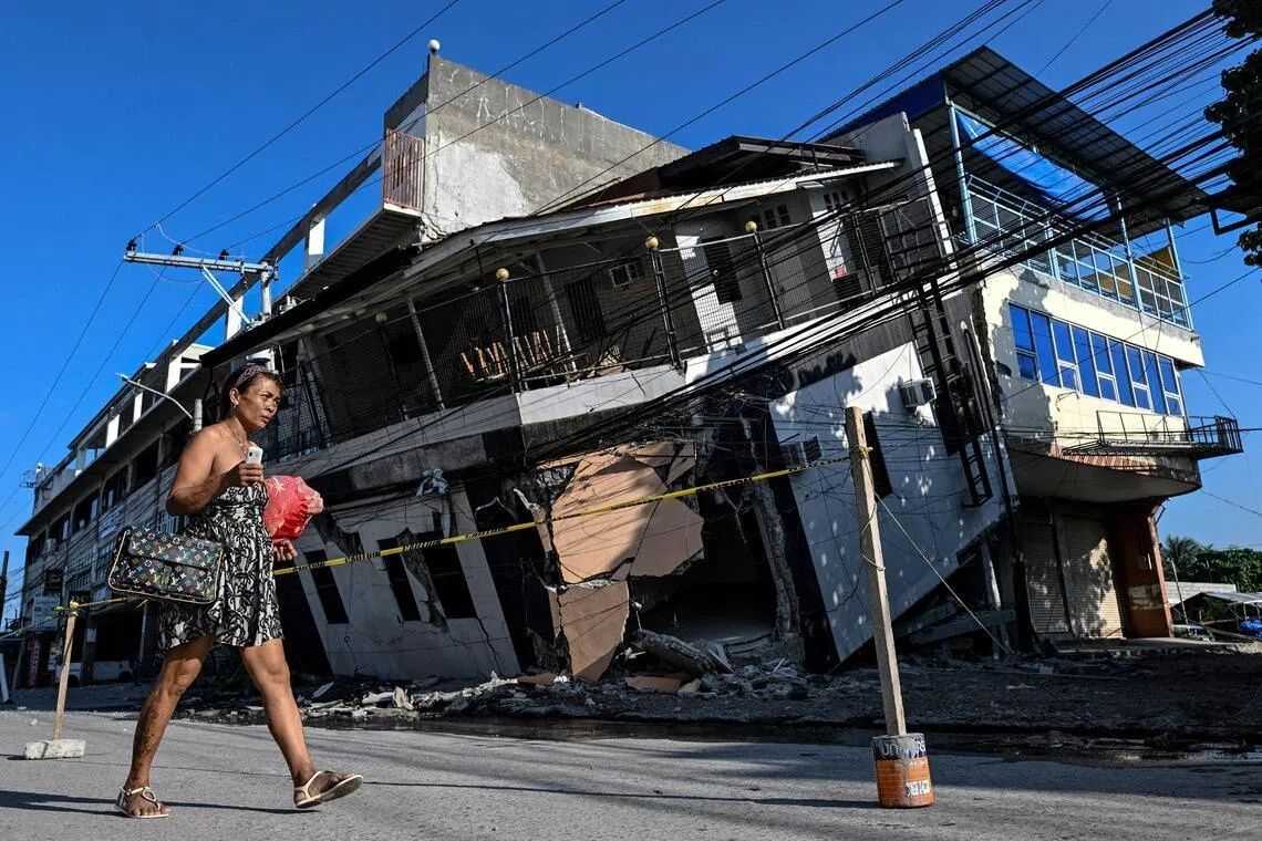
When Arsenio Butil Jr. felt the ground violently shake beneath his feet on June 8, the fisherman and pastor in Glan, Sarangani province, dropped to his knees in prayer. As the tremors subsided and he opened his eyes, he witnessed something extraordinary and deeply unsettling: the shoreline of his home was visibly transforming before him, with vast expanses of previously submerged coral reef suddenly breaching the surface of the water. This surreal scene would repeat itself across the southern island of Mindanao, where a 7.8 magnitude earthquake proved to be among the most destructive natural disasters the region has experienced in recent years, claiming at least 76 lives and triggering a cascade of secondary hazards including landslides and widespread structural damage.
The earthquake was generated by the Cotabato Trench, a major fault line situated as close as 50 kilometres offshore from Mindanao, which has long been recognised as a zone of intense seismic activity. This particular rupture initiated a phenomenon known as coastal uplift, wherein tectonic forces thrust substantial sections of the island's coastline upward in a single, dramatic movement. The visual evidence of this geological upheaval was unmistakable: fishing vessels that had previously floated at the water's edge now sat stranded on the wrong side of walls of jagged, bleached coral that stretched for kilometres along the newly exposed seabed. For communities that had depended on the sea for generations, the transformation was both stunning and deeply troubling.
According to Nane Danlag, a seismologist at the Philippines' seismology centre, the seabed rose approximately two metres during the event, resulting in a permanent extension of the shoreline by roughly 200 metres in certain locations based on preliminary measurements. Danlag emphasised that this shift represented the area's new, permanent coastal baseline—a dramatic geological restructuring that would define the landscape for decades to come. The affected zone stretched across approximately 100 kilometres, spanning the territory between two towns and impacting multiple fishing communities and coastal settlements simultaneously. While the scale of the physical change was extraordinary, Danlag noted that such movements have been occurring naturally in this region for thousands of years, albeit typically over much longer geological timescales.
Butil Jr. provided a vivid account of the quake's immediate effects, describing how the water receded and advanced repeatedly—perhaps three or four times—as the earth convulsed beneath the waves. He witnessed dead fish floating to the surface, their bodies unable to survive the sudden, violent alteration of their environment. The experience left residents profoundly shaken, with panic spreading throughout the coastal settlements as people struggled to comprehend the scale and nature of the disaster unfolding around them. The earthquake represented the most powerful tremor Butil Jr. had experienced in his entire lifetime, a sobering reminder of the raw geological forces at work beneath the peaceful archipelago.
The seismic warning signs had been present weeks earlier. In January, the Cotabato Trench exhibited a "swarm" of thousands of predominantly minor earthquakes, a pattern that prompted the United Nations to issue a disaster risk reduction report in mid-May suggesting these tremors could potentially herald a major seismic event. Despite this advisory, the arrival of the 7.8 magnitude earthquake still caught many communities unprepared for the sheer scale of destruction and the unprecedented coastal transformation that would follow. The prophetic nature of the UN's assessment underscores the importance of seismic monitoring in the Philippines, a nation that sits along the Pacific Ring of Fire and faces persistent earthquake hazards.
In the hills overlooking a neighbouring village, approximately 100 residents—men, women, and children—had sought refuge on higher ground when the initial tremors struck and remained encamped there days later. Datu Atom Malimpnig, a Maguindanaon tribal chieftain representing the displaced group, explained that the community of fishermen and their families had become reluctant to descend to their now-destroyed homes. The uncertainty surrounding potential tsunami waves compounded their anxiety; despite the earthquake having concluded, many residents harboured legitimate fears that the sea might surge forward with destructive force, exploiting the newly restructured coastline. These concerns kept them in their temporary hilltop encampment, where government relief workers distributed rice porridge and other emergency aid, a far cry from the stable lives they had previously led near the shore.
The economic implications of the coastal uplift extended beyond displaced families to the tourism sector, which forms an integral component of the region's economy. At the Isla Jardin del Mar resort, staff member Edzel Baylon confronted a newly transformed landscape that fundamentally threatened the establishment's core business model. The resort's primary appeal had always centred on its white sand beach, an idyllic setting that attracted visitors seeking tropical island experiences. However, the earthquake-induced uplift had separated the once-picturesque beachfront from the water itself by a barrier of exposed coral skeleton. The sea, which had previously provided the visual and recreational anchor for the resort's offerings, now appeared distressingly shallow and unsuitable for swimming. This transformation represented not merely an aesthetic setback but a potential economic catastrophe for a business dependent on marine tourism.
The seismic activity showed no signs of abating. Since the June 8 main shock, the seismology agency recorded more than 8,500 aftershocks rippling through the region, maintaining a state of elevated geological instability that prevented residents from relaxing their vigilance or commencing reconstruction efforts with confidence. These continued tremors, ranging from imperceptible micro-seismic events to more noticeable jolts, kept communities on edge and reinforced the perception that danger remained imminent. Such prolonged aftershock sequences are common following major earthquakes but nevertheless contribute substantially to psychological trauma and hinder recovery operations.
In Glan and surrounding communities, residents found themselves facing a profound dilemma regarding reconstruction and future habitation. Butil Jr. noted that the ground remained severely fractured, with long cracks extending across the landscape, rendering any attempt to rebuild homes in these areas extraordinarily hazardous. The prospect of another major earthquake striking while structures were being repaired or newly constructed posed a nightmarish scenario for families desperate to reclaim their homes. The uncertainty about when seismic activity might subside made long-term planning virtually impossible, leaving residents in a state of paralysis—unable to move forward with rebuilding yet unable to safely remain in their previous settlements. These communities now face a prolonged period of displacement and uncertainty as they grapple with both the immediate aftermath of destruction and the longer-term challenge of determining whether, when, and how to rebuild in a geologically unstable environment that has been fundamentally transformed by forces beyond human control.