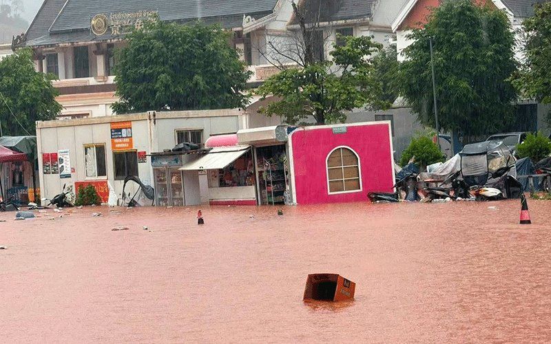
Luang Namtha province in northern Laos has been designated a disaster zone following devastating flash floods that surged across the Laos-China border crossing at Boten on Saturday, 29 August. The provincial administrative authorities made the declaration after widespread inundation affected more than 30 villages across Luang Namtha and Nalae districts, with floodwaters damaging residential structures, commercial facilities including a special economic zone, agricultural land, and essential public infrastructure. The actual border checkpoint itself managed to escape the worst of the deluge, though the broader region surrounding it experienced significant water damage.
The destruction brought by the rapidly moving floodwaters extended to numerous critical installations throughout the affected areas. Schools and hospitals in multiple communities found themselves partially or fully inundated, disrupting essential services when they are most needed. Agricultural regions suffered extensive losses as farmland was submerged under metres of murky water, a particularly severe blow to communities dependent on farming and food production. Airport facilities in the province also sustained damage, though the extent of operational disruption remains to be fully assessed. The scale of damage suggests this was not merely a localised flooding event but rather a major hydrometeorological disaster affecting the region's infrastructure network.
The immediate cause of the flooding lay in the behaviour of upstream river systems, which began rising dramatically after several consecutive days of heavy rainfall in the region and across the border in southwest China. Water from swollen rivers flowed southward into Laotian territory with considerable force. The Tha River, one of the critical waterways in the area, reached particularly concerning levels measured at a hydrology station on Saturday. The recorded depth of 6.58 metres exceeded the established 6-metre flood warning threshold and approached the critical 7-metre level that triggers maximum alert responses. These measurements indicated that the flooding was not a minor weather event but rather approached severe emergency conditions.
Recognising the ongoing threat, the Department of Meteorology and Hydrology operating under Laos's Ministry of Agriculture and Environment issued formal flood warnings for the Tha River specifically for the period of 29-30 August. The warning system activated provincial authorities across five districts, instructing local administrators to immediately inform all residents situated along riverbanks, in topographically low areas, and other high-risk locations. These notifications carried the directive to prepare for potential evacuation orders should river levels continue their upward trajectory. The precautionary messaging represented a standard but essential response to hydrological emergencies, designed to ensure communities had adequate notice to move to safety if circumstances deteriorated further.
Local government officials received explicit instructions to intensify their monitoring of the flood situation in real time, enabling rapid responses to emergencies as they developed. The protocols emphasised the importance of swift incident response and established mandatory regular reporting channels to provincial headquarters, ensuring that senior administrators maintained current awareness of ground conditions across affected areas. Television announcements disseminated these directives to the broader public, ensuring that communities understood the official response framework and the level of alert authorities considered appropriate. This multi-layered communication strategy attempted to balance transparency with operational effectiveness during the crisis period.
The flooding situation extended beyond Luang Namtha itself, as a broader meteorological system threatened an expansive area across Laos and the Chinese border region. The low-pressure system moving across northern Laos and southwest China, when combined with the prevailing south-westerly monsoon circulation, created conditions conducive to significant precipitation and severe weather phenomena. Forecasters predicted scattered thunderstorms would develop, accompanied by moderate to heavy rainfall and potentially damaging wind gusts. This combination of factors meant that the weekend ahead would remain treacherous across much of northern Laos.
The geographic scope of weather risk was remarkably extensive, encompassing 14 provinces across Laos. The threatened provinces included Phongsaly, Huaphan, Luang Prabang, Luang Namtha, Oudomxay, Xaysomboun, Bolikhamxay, Khammuan, Savannakhet, Salavan, Xekong, Champasak, Attapeu and Vientiane. This list effectively covered much of the nation from its northern borders southward through the central and southern regions, underscoring that the meteorological system represented a national-scale weather event rather than a purely localised phenomenon. Communities across this expansive territory faced similar hazards from flash flooding and slope failure.
Meteorological agencies urged residents throughout these vulnerable zones to maintain heightened vigilance regarding weather developments. Authorities advised populations to monitor official weather forecasts continuously, as conditions could change rapidly and dangerously. The public guidance specifically highlighted the twin dangers of flash floods and landslides as the principal threats during the weekend period. Residents dwelling adjacent to rivers or situated in valleys and other topographically susceptible locations were particularly encouraged to assess their circumstances and prepare contingency plans, including identifying safe evacuation routes and shelter options in case emergency relocation became necessary.
For Malaysia and the broader Southeast Asian region, this flooding episode in Laos carries particular significance given the interconnected nature of monsoon systems and transboundary river management in mainland Southeast Asia. The Mekong River basin, of which Laotian rivers form an essential component, influences water availability and flood risk across Thailand, Cambodia, and Vietnam downstream. Laotian disasters thus reverberate through the region's water security architecture. Additionally, the Laos-China border area represents a strategically important economic zone for both nations, with the Boten special economic zone serving as a significant trade corridor. Disruptions to this infrastructure could affect regional trade patterns, particularly for Malaysian companies with supply chain exposure to Laotian and Chinese markets. The incident also demonstrates the vulnerabilities of border infrastructure to natural hazards, a consideration relevant to Southeast Asian nations managing transboundary resources and development zones in monsoon-exposed regions.

