Kuala Lumpur City Hall (DBKL) has begun the permanent shutdown of two traffic light-controlled intersections along Jalan Ampang, namely the junction fronting the Royal Thai Embassy and the Lorong Ampang 2 crossing, as part of an ambitious infrastructure modernisation initiative that officially commenced on July 1. The decision marks a significant step in the city's ongoing efforts to decongest one of Kuala Lumpur's busier east-west arterial routes and improve the urban transport experience for commuters and businesses relying on this corridor.
The closure forms the centrepiece of DBKL's comprehensive 3.2-kilometre Jalan Ampang upgrade project, which stretches from the Jalan Tun Razak intersection eastward to the Middle Ring Road 2 (MRR2) junction. This substantial investment in road infrastructure reflects the municipal authority's broader commitment to modernising Kuala Lumpur's transport network as the city grapples with congestion challenges exacerbated by urban sprawl and increasing vehicle ownership. The upgrade programme is designed not merely as a reactive measure to manage existing traffic problems, but as a proactive reimagining of how this critical corridor functions within the larger metropolitan transport ecosystem.
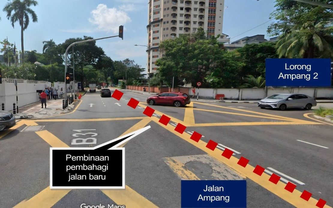
The underlying philosophy of the project centres on creating a more systematised and efficient road network. Rather than simply widening existing pavement, DBKL is implementing a holistic approach that encompasses structural enhancements targeting both vehicular and pedestrian users. The construction of permanent road dividers will fundamentally reshape how traffic behaves on Jalan Ampang, preventing the erratic lane-changing and merging manoeuvres that currently characterise the corridor during peak hours. These dividers will enforce more disciplined traffic separation, reducing the risk of collisions caused by abrupt directional changes.
The upgrade encompasses the transformation of Jalan Ampang into a four-lane, two-way thoroughfare with upgraded specifications throughout its entire project length. This reconfiguration moves beyond merely increasing vehicle capacity; it establishes clearer spatial hierarchy between different transport modes. Pedestrian infrastructure receives particular attention, with the design incorporating wider and more ergonomically comfortable walkways that meet contemporary urban design standards. Enhanced street lighting represents another significant component, addressing safety concerns that have long plagued various sections of the corridor, particularly during evening hours and in areas with dense foot traffic.
The permanent closure of the two intersections carries implications extending far beyond the immediate locales. By eliminating these traffic light-controlled junctions, DBKL aims to substantially reduce what traffic engineers term "weaving conflicts"—the complex manoeuvres required when vehicles must navigate multiple lane changes to reach their intended exit points. Such conflicts are a primary source of congestion and accident risk in urban environments. The removal of signalised intersections paradoxically can improve overall traffic flow by eliminating the stop-start patterns that create shockwaves rippling backward through traffic queues. This represents a shift toward arterial road design philosophy that prioritises continuous, uninterrupted movement over frequent deceleration and acceleration cycles.
The anticipated reduction in intersection delays is particularly significant for Jalan Ampang, which serves as a vital link between the eastern suburbs and the central business district. Commercial establishments, office complexes, and residential areas throughout the corridor depend on reliable travel times. By smoothing traffic flow and reducing bottleneck points, the upgrade promises to deliver tangible benefits to businesses and commuters alike. For freight operators and delivery services, more predictable travel times translate directly into improved operational efficiency and reduced logistics costs.
DBKL has implemented a structured communication strategy to mitigate disruption during the transition period. Alternative routing options have been explicitly designated and publicised to accommodate the permanent closure. Eastbound traffic heading toward Ampang can execute U-turns at Jalan Tun Razak to reverse direction, while westbound traffic destined for the city centre has been provided with a designated U-turn facility at Jalan Ampang Hilir. These alternative routes, while not eliminating the need for some drivers to alter their usual paths, are intended to distribute displaced traffic across the existing road network in ways that prevent acute congestion concentrating at any single point.
For Malaysian motorists accustomed to navigating Kuala Lumpur's increasingly complex road system, the closure underscores the continuing evolution of urban transport infrastructure. The capital's road network has undergone numerous similar transformation projects in recent years, reflecting the perpetual tension between preserving smooth traffic flow and accommodating growing transportation demand. Public acceptance of such disruptions often hinges on clear communication about the long-term benefits and temporary inconveniences, a factor that DBKL has acknowledged through its public advisory messages.
The success of this upgrade project will likely influence future transportation planning decisions across Kuala Lumpur and potentially other Malaysian cities. Should the Jalan Ampang modernisation achieve its stated objectives of improved efficiency and safety, similar intersection closure and road-restructuring initiatives may become more common in other congested corridors. This represents an important case study in how municipal authorities balance the short-term costs of infrastructure disruption against long-term gains in traffic performance and urban livability.
The broader significance of this project extends into the realm of sustainable urban development. By engineering a road environment that encourages smoother traffic flow with fewer stops and starts, fuel consumption patterns may improve marginally, with corresponding environmental benefits. Enhanced pedestrian facilities also support the city's objectives to encourage non-vehicular transport modes, though success in this dimension depends on complementary investments in public transit connectivity and urban planning that supports mixed-use development patterns.
Drivers and regular Jalan Ampang users are being advised to familiarise themselves with the new traffic configuration and to strictly adhere to all directional signage installed throughout the project zone. Such compliance is essential not only for personal safety but also for the success of the traffic management strategy underlying the road closure. DBKL continues to monitor conditions along the corridor and has indicated readiness to make adjustments to the alternative routing arrangements should unforeseen congestion patterns emerge during the initial implementation phase.