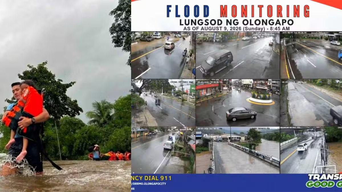
The Philippines is grappling with a severe natural disaster as relentless rains from the southwest monsoon, locally known as the habagat, combine with the influence of two tropical cyclones to create catastrophic flooding conditions across multiple regions. Authorities mobilised emergency personnel and resources throughout Sunday to respond to the unfolding crisis, with rescue operations intensifying in flood-ravaged communities where residents face mounting dangers from surging waters and secondary hazards such as landslides and electrocution.
The scale of displacement reflects the emergency's gravity. The National Disaster Risk Reduction and Management Council reported that at least 382,000 people—comprising roughly 110,000 families—have been impacted by the flooding. The majority of those affected hail from eight distinct regions distributed across Luzon and Mindanao, the two largest island groups in the archipelago. This dispersed impact pattern underscores the monsoon's reach and the vulnerability of populations across multiple provinces to extreme weather events.
Tragedy has marked the disaster, with at least nine fatalities recorded by Sunday. Among the victims was a police officer in Negros Occidental who lost his life while attempting to rescue two colleagues from the turbulent currents of a swollen river—a stark reminder of the hazards faced by those on the frontlines of rescue efforts. A 28-year-old man from Cuenca, Batangas, died after reportedly being electrocuted while traversing a flooded section of J.P. Laurel Highway in Lipa City on Saturday night, highlighting how monsoon-induced disasters create multiple layers of danger. Seven additional deaths resulted from drowning and landslide incidents scattered across Luzon's provinces, including a minor who drowned in Candon City, Ilocos Sur, and residents from La Union, Pangasinan, Benguet, and Rizal.
The meteorological outlook offers little relief to affected communities. The Philippine Atmospheric, Geophysical and Astronomical Services Administration issued an evening advisory on Sunday cautioning that heavy rainfall driven by the southwest monsoon would persist through Wednesday of the following week. Particularly concerning is the forecast for intensified precipitation in mountainous and elevated terrain, where the combination of heavy rain and steep topography creates conditions conducive to flash flooding and landslides. Forecasters also warned that areas already saturated by significant rainfall face heightened risk of worsening impacts, suggesting that cumulative precipitation could push drainage systems beyond their capacity in vulnerable zones.
The dual tropical cyclone influence—Tropical Depression Luis and Tropical Storm Maymay, known internationally as Kujira—has amplified the monsoon's destructive potential. The Philippine Atmospheric, Geophysical and Astronomical Services Administration has issued successive rainfall warnings for Metro Manila and surrounding provinces since Friday, reflecting the complex interaction of multiple weather disturbances converging over the country. This convergence of systems represents precisely the type of scenario that generates extreme precipitation events and cascading secondary disasters.
Critical infrastructure has reached alarming thresholds as water accumulation becomes pronounced. The Angat Dam in Norzagaray, Bulacan—a vital reservoir serving Metro Manila and surrounding regions—experienced a dramatic rise of nearly 15 metres within ten days, climbing from 161.30 metres above sea level at dawn to 164.80 metres by mid-afternoon on Sunday. This sharp ascent contrasts sharply with the reservoir's record-low level of 150.61 metres recorded on July 30, illustrating the severity of the current inflow. The downstream Ipo Dam similarly approached its critical spilling threshold at 101 metres above sea level, releasing 314.91 cubic metres of water per second as authorities managed the cascading water flow through the dam system.
Regional impacts reveal the breadth of the disaster's reach across diverse terrain and communities. In Bulacan, nearly 1,000 residents evacuated from multiple towns and cities as flooding intensified by tidal surge penetrated communities, with floodwaters reaching approximately 1.2 metres in certain localities. The Bulusan Riverbank in Calumpit became impassable for light vehicles, severing transport routes and isolating affected populations. Central Luzon experienced inundation across 98 villages, affecting approximately 170,000 individuals, while pre-emptive evacuations moved 781 families totalling 2,544 people from Nueva Ecija and Zambales. In Calabarzon region, over 7,000 families confronted the waters, with 3,134 families sheltering in 117 evacuation centres distributed across 29 localities. The geographic spread from Central Luzon through Calabarzon demonstrates how a single weather system can overwhelm multiple regional administrations simultaneously.
Specific hazards have compounded difficulties in various provinces. Two bridges in Cagayan became impassable as the Chico River surged beyond safe levels, while Nueva Vizcaya, Abra, and Mountain Province faced road closures from landslides and rockfalls triggered by saturated soil conditions. In Benguet, La Trinidad experienced floodwaters rising to approximately 0.6 metres in Barangay Pico, with water penetrating residential structures and disrupting daily life. The Quimmarayan River in Santo Domingo, Ilocos Sur, approached overflow status as accumulated debris from upstream areas clogged the passage beneath Nambaran Bridge, requiring emergency clearance operations and heightened monitoring of downstream flood-prone communities.
Breaches in flood-control infrastructure have proved particularly consequential. In San Marcelino, Zambales, both flooding and lahar—the dangerous slurry of volcanic materials—cut off entire communities after a protective dike failed under pressure from swollen waters. A bridge in Barangay Santa Fe was destroyed by powerful currents, severing access routes. Wind damage accompanied the water hazard, with at least eleven houses and a barangay multipurpose hall damaged by strong gusts in San Antonio. In Iloilo City, a suspected tornado combined with monsoon-force winds damaged at least 52 houses, toppled trees and utility poles, and forced displacement of over 150 residents.
Transportation networks have experienced severe disruption at both terrestrial and maritime levels. The Philippine National Police reported that extensive flooding and severe congestion have crippled major thoroughfares across Luzon, forcing municipal government units to conduct emergency evacuations and divert traffic around inundated roads. At sea, the Philippine Coast Guard documented the stranding of 543 individuals—including passengers, truck drivers, and cargo handlers—at 28 ports spanning four coastal regions, effectively halting inter-island commerce and passenger movement during the crisis period.
PNP chief General Jose Melencio Nartatez Jr. announced the mobilisation of expanded police personnel and resources for evacuation operations and broader disaster response measures, appealing to the public to maintain composure while remaining attentive to official guidance. He urged communities to rely exclusively on verified information from official channels and avoid circulating unconfirmed online reports that risk generating unnecessary panic and hampering coordination efforts among emergency responders.
The disaster has reignited political criticism regarding infrastructure preparedness. The Makabayan coalition asserted that the failures exposed in current flooding events reflect inadequacies in infrastructure projects under the Marcos Jr. administration, particularly flood control initiatives that have proven insufficient when tested by extreme weather. The coalition pressed for heightened oversight of unprogrammed appropriations as the legislature deliberates the 2027 national budget, arguing that such discretionary spending mechanisms have historically facilitated pork barrel allocations that enable corruption among elected representatives.
For Malaysian observers, this Philippine calamity underscores the shared regional vulnerability to monsoon systems and tropical cyclones affecting Southeast Asia during specific seasonal windows. The crisis demonstrates how inadequate drainage infrastructure and flood-control systems can magnify the destructive potential of natural weather patterns, offering sobering lessons for countries throughout the region as climate variability intensifies. The coordination challenges facing Philippine emergency managers—involving multiple regional administrations, national agencies, and port authorities across dispersed geography—mirror logistical complexities that Malaysian authorities might encounter during comparable regional weather emergencies.

