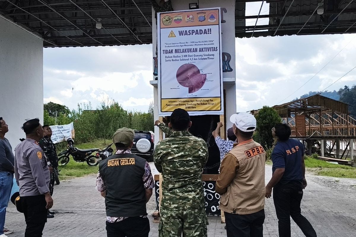
Indonesia's Karo regency has temporarily shuttered two major tourism attractions—Lau Kawar Lake and an adjacent camping facility in Kuta Gugung village—in response to escalating seismic and volcanic activity at Mount Sinabung. The decision, which took effect from August 19, reflects growing official concern about the mountain's unpredictable behaviour and represents a precautionary approach to safeguarding both visitors and nearby residents from potential hazards.
Local authorities, acting on expert recommendations from the Vulcanology and Geological Disaster Mitigation Center's monitoring post dedicated to the volcano, imposed the closure for an indefinite period. Juni Antomi Kemit, head of the Karo Youth Affairs, Sports and Tourism Agency, characterised the temporary shutdown as a protective measure necessitated by the volcano's heightened activity levels. The closure follows a public announcement issued by the Karo regent on August 14, which explicitly advised residents, tourists, and mountaineers to refrain from any activities within the volcano's vicinity.
The shift from a dormant state to observable volcanic behaviour marks a significant development. Armen Putra, the monitoring post commander responsible for tracking Mount Sinabung's status, confirmed that alert levels have been officially upgraded from Level I Normal to Level II Waspada, placing the volcano in an advisory category within Indonesia's four-tiered warning system. This escalation means authorities are recommending that people maintain a minimum safe distance of three kilometres from the mountain's summit, with an even more restricted exclusion zone extending 4.5 kilometres into the south-east sector where pyroclastic flows pose particular danger.
The monitoring data itself reveals why officials are taking these precautions seriously. As of late August, Mount Sinabung exhibited multiple warning signs: tremors registered with varying intensity, visible smoke columns reaching heights between 100 and 800 metres above the crater, and notably increased earthquake frequencies. Thursday's early morning measurements detected five volcanic earthquakes originating from within the mountain's magmatic system, in addition to deeper tectonic earthquakes. By comparison, the previous day had recorded only one volcanic earthquake alongside seven tectonic events, demonstrating the rapid acceleration in activity. Experts recognise that the proliferation of such seismic events typically correlates with rising magmatic pressure and greater potential for eruption.
Residents dwelling along riverbanks that originate on Mount Sinabung's slopes have been specifically cautioned to remain alert for lahars—destructive mud flows composed of volcanic debris mixed with water that can travel at high speeds down drainage systems. These hazards present particular danger to downstream communities and represent one of the volcano's most lethal secondary effects.
Mount Sinabung's contemporary threat must be understood within its recent geological history. After remaining dormant for approximately four centuries, the 2,460-metre peak unexpectedly reawakened on August 29, 2010, catching many regional observers by surprise. Following that initial eruption, seismic activity subsided by September 2010, creating a temporary sense of stability. However, this respite proved temporary; the volcano erupted again on September 15, 2013, then descended to alert Level II before escalating dramatically in November 2013.
The November 2013 eruption represented a watershed moment in the volcano's recent cycle. That catastrophic event triggered the highest alert level classification—Level IV Awas—and resulted in dozens of fatalities from pyroclastic flows, which are superheated avalanches of gas and rock that move at extreme velocities. The eruption necessitated the evacuation of approximately 21 villages and two hamlets, displacing thousands of people from their homes and livelihoods. This eruption demonstrated Mount Sinabung's capacity to inflict serious harm on surrounding communities and underscored why contemporary authorities treat warning signs with utmost seriousness.
Following that devastating 2013 event, Mount Sinabung entered an extended period of nearly continuous eruptive activity spanning six years. This prolonged restlessness only gradually subsided, prompting authorities to lower the alert classification to Level III Siaga on May 20, 2019, after comprehensive analysis of both visual observations and instrumental data suggested the immediate threat was diminishing. That reprieve, however, proved limited in duration. In July 2021, the volcano erupted once more, ejecting ash columns reaching 4,500 metres altitude and generating pyroclastic flows extending 1,000 metres toward the east-southeast. This eruption, the most significant since 2013, affected at least five districts beneath thick blankets of volcanic ash and represented the volcano's most recent major outburst after eleven years of intermittent activity.
For Malaysia and the broader Southeast Asian region, Mount Sinabung's resurgence carries particular significance. Transboundary impacts from major Indonesian volcanic eruptions have historically affected neighbouring countries, particularly regarding atmospheric ash dispersal and potential climate effects. The tourism closure also underscores how geological hazards can disrupt regional travel patterns and economic activity, given that Mount Sinabung attracts visitors from across Southeast Asia seeking adventure tourism and natural attractions.
The current escalation suggests that Mount Sinabung has not settled into permanent quiescence but rather exhibits cyclical behaviour characteristic of complex volcanic systems where extended quiet periods can be punctuated by sudden, dangerous awakenings. Authorities appear determined to avoid complacency, implementing precautionary measures well before any imminent eruption becomes certain. This approach reflects lessons learned from previous eruptions and represents a shift toward more proactive risk management in densely populated volcanic regions, prioritising early intervention over reactive emergency response.

