Japan's weather authorities issued urgent warnings Friday as the nation prepared to face a dual typhoon threat over the weekend, with Typhoon Higos expected to make landfall while Typhoon Mekkhala simultaneously menaced population centers across the country. The Japan Meteorological Agency cautioned that the dangerous weather system approaching from the Pacific would strike shortly after another cyclone pressed toward southwestern regions, creating a compounding meteorological hazard that forced evacuation orders affecting millions of residents.
The timing of these concurrent weather events presented an unusual challenge for disaster management officials, as both typhoons were expected to approach Japan with overlapping influence areas. Typhoon Higos was positioned to make its approach from the southern coast and move northward through the country's interior, while Typhoon Mekkhala, already impacting the Amami region in Kagoshima Prefecture on Friday morning, threatened to advance toward the densely populated Kanto metropolitan region encompassing Tokyo and surrounding areas. This dual trajectory meant that different regions would face severe weather conditions simultaneously rather than sequentially, complicating evacuation and emergency response efforts.
By Friday morning, the Fire and Disaster Management Agency reported that evacuation orders had been issued for more than 2 million individuals distributed across 13 prefectures spanning the Kinki and Kyushu regions. The scale of the precautionary measures underscored the severity with which authorities regarded the approaching weather systems. In particularly vulnerable areas, emergency alerts reached the highest severity level: Seika in Kyoto Prefecture activated its maximum level 5 safety alert following a landslide that struck the town during early morning hours, highlighting how the preliminary rainfall was already triggering secondary hazards before the main typhoon systems arrived.
Rainfalls leading up to the weekend had already produced substantial accumulations across multiple prefectures, creating saturated soil conditions that increased vulnerability to further landslides and flooding. The Goto region in Nagasaki Prefecture recorded 600 millimetres of precipitation between Tuesday and Friday morning alone. Similarly, the Aso area in Kumamoto Prefecture and Ureshino in Saga Prefecture each experienced more than 500 millimetres during the same period. These substantial accumulations, arriving ahead of the typhoons' main impact, had already destabilized slopes and overwhelmed drainage systems in numerous localities, setting the stage for intensified hazards when the typhoons arrived.
Meteorological forecasts indicated that rainfall would accelerate sharply as both typhoon systems approached their respective impact zones. The Tokai region, situated between the anticipated path of Typhoon Higos and facing exposure to moisture from Typhoon Mekkhala's circulation, was forecast to receive up to 300 millimetres of additional rain by Saturday noon. The Kanto-Koshin region, encompassing greater Tokyo, was expected to experience up to 150 millimetres, representing a significant precipitation event even by Japanese standards. The concentration of this rainfall into a compressed timeframe, combined with already-elevated baseline moisture levels, created conditions conducive to flash flooding and mass movement hazards across infrastructure-heavy regions.
Both meteorological systems were expected to gradually weaken into extratropical cyclones after approaching Japan, though the Japan Meteorological Agency cautioned that this transition would not substantially diminish associated hazards. Even as the typhoons lost tropical characteristics and transitioned to mid-latitude cyclonic systems, they would retain the capacity to generate strong winds, heavy precipitation, and secondary geohazards including landslides and flooding. The warning reflected understanding that the danger period extended beyond the period of maximum intensity, as weakening systems could still produce dangerous conditions, particularly when overlapping with saturated ground conditions.
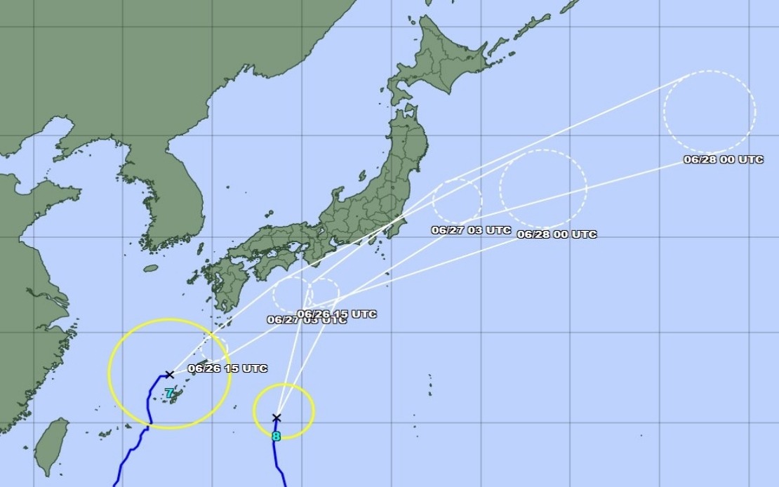
As of Friday late morning, Typhoon Mekkhala was positioned northeast of Kume Island off Okinawa Prefecture's coast, advancing northeastward at 15 kilometres per hour. This positioning and forward speed trajectory suggested that the system would continue its progression toward the Kanto region throughout Friday and into Saturday. The measured advance rate indicated that maximum impacts would likely occur during Saturday, aligning with forecasts of heaviest rainfall in principal affected regions during that period. Okinawa Prefecture and eastern Japan broadly were already experiencing strong storms as the systems' outer circulation bands reached those areas.
For Malaysian and broader Southeast Asian observers, Japan's typhoon response mechanisms and the scale of evacuation efforts highlight both the sophistication of disaster preparedness infrastructure in developed nations and the continuing vulnerability of densely populated regions to tropical cyclone impacts. Japan's early warning systems, established building codes, and practiced evacuation procedures represent best practices in typhoon preparedness, yet even with these measures, dual simultaneous systems created coordination challenges and multiplied impacts. The scale of precautionary evacuation—affecting over 2 million people—demonstrates how typhoons justify cautious rather than wait-and-see approaches in meteorologically exposed nations.
The simultaneous approach of two distinct tropical cyclone systems also underscores changing patterns in typhoon behavior and frequency that have characterized recent decades. While the co-occurrence of major systems is not unprecedented, the regularity with which multiple significant typhoons operate within the Western Pacific basin during a single season has drawn increased attention from climate researchers. For Southeast Asia, where typhoons and monsoon interactions drive seasonal weather patterns and can occasionally produce dual-system scenarios, Japan's experience provided relevant insights into how infrastructure and emergency management systems handle compounding meteorological hazards.
Beyond immediate weather impacts, the dual-typhoon scenario tested the limits of Japan's evacuation and shelter capacity, logistics networks, and inter-prefectural coordination mechanisms. Emergency management officials faced decisions about shelter prioritization, resource allocation across affected regions, and communication strategies to ensure public compliance with evacuation orders while managing information flow during an active, evolving threat. These operational dimensions of disaster response often receive less attention than meteorological aspects but critically determine whether precautionary measures successfully protect lives and minimize economic disruption.