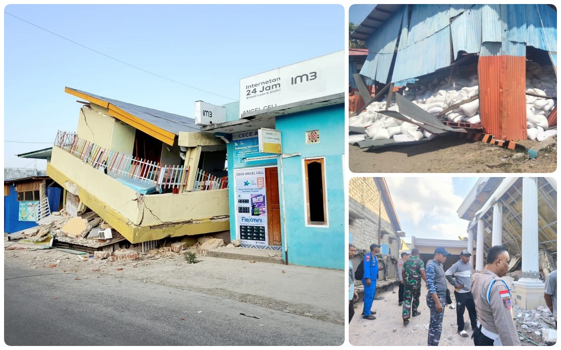
A devastating magnitude 7.7 earthquake shook Indonesia's Flores Island in the early hours of Sunday, triggering a cascade of seismic activity that has left the region reeling. The tremor, which struck at 4.58 am local time with its epicentre located about 30 kilometres offshore from Mbay in Nagekeo district at a depth of 15 kilometres, has claimed at least 53 lives across seven affected regencies and cities. The disaster has displaced thousands of residents, many of whom remain at evacuation centres even as rescue and recovery operations continue into their second day.
The scale of the aftershock activity underscores the earthquake's intensity and the ongoing geological instability affecting the region. According to the National Disaster Management Agency (BNPB) Deputy for Prevention Abdul Muhari, the Meteorology, Climatology and Geophysics Agency (BMKG) had registered 995 aftershocks by Sunday afternoon, though only a fraction of these were perceptible to the population. This relentless seismic sequence, though mostly minor, has exacerbated public anxiety and complicated rescue and assessment efforts. The sheer number of tremors serves as a stark reminder of the tectonic pressures at work beneath the Indonesian archipelago, one of the world's most seismically active regions.
The human toll extends beyond immediate deaths and injuries. With 135 people wounded and no missing persons officially reported, authorities have managed to account for the affected population across the disaster zone. However, the psychological impact of the earthquake has proven significant, particularly given Flores Island's traumatic history. The 1992 Flores earthquake and tsunami, which killed over 2,000 people, remains seared in local memory. This historical trauma has influenced current resident behaviour, with many choosing to remain at evacuation sites despite assessments indicating the immediate danger has passed, fearing both renewed seismic activity and the possibility of additional aftershocks causing further structural damage.
Property destruction has been substantial, with numerous homes damaged across the affected areas. The BNPB reported that as of midnight Saturday, approximately 9,290 people were sheltering at evacuation sites. Abdul Muhari emphasised that authorities were continuing to update casualty figures as emergency response operations unfolded, with comprehensive damage assessments still underway. The scale of displacement reflects not only the earthquake's immediate physical impact but also the precautionary measures taken by residents wary of returning to structurally compromised dwellings. Authorities have prioritised providing affected residents with basic supplies and establishing proper shelter facilities.
Infrastructure damage has severely hampered access to affected regions. A critical section of road in Reok, Manggarai, which had been rendered impassable by landslides triggered by the earthquake, was restored to allow fuel tanker trucks to pass through. This achievement proved essential for maintaining supply chains to evacuation centres and medical facilities. Electrical systems across multiple affected areas experienced blackouts immediately following the quake, though restoration efforts have progressively restored power to several communities. These infrastructure challenges highlight the cascading effects of seismic disasters in remote island regions, where recovery depends heavily on restoring basic connectivity and services.
The initial tsunami threat, while ultimately not materialising into a major wave event, added to the immediate crisis. The BMKG issued a tsunami warning following the earthquake but lifted it at 7.31 am after monitoring sea-level observations indicated no significant rise beyond normal variations. This rapid assessment and communication prevented unnecessary panic, though it underscored the dual hazards facing island communities vulnerable to both seismic and oceanic disturbances. The experience reinforces the critical importance of robust early warning systems across the Indonesian archipelago.
Emergency response coordination has been mobilised across multiple levels of government and agencies. The BNPB established dedicated response posts in both Labuan Bajo and Maumere, the principal population centres in the affected region, alongside logistics hubs in Jakarta to coordinate the distribution of relief materials and personnel. The National Search and Rescue Agency (Basarnas) has been actively involved in search and recovery operations, and the absence of reported missing persons represents a significant achievement in accounting for the population. Abdul Muhari confirmed during a press conference that as of Sunday, no missing person cases had been formally registered, indicating effective population tracking during evacuation.
Aircraft and helicopters have been positioned on standby to support ongoing relief operations if required, a prudent measure given the region's geographical challenges and the potential for further complications. The deployment of multi-agency resources reflects Indonesia's institutional response capacity for natural disasters, though the scale of displacement and property damage suggests prolonged recovery requirements. Transportation bottlenecks and logistical constraints remain ongoing concerns as authorities work to deliver supplies and facilitate the return of displaced residents to their homes once structural assessments confirm safety.
For Malaysia and other Southeast Asian nations, this disaster underscores shared regional vulnerabilities to seismic activity. The Ring of Fire's influence extends across the broader region, and the incident serves as a reminder of the importance of disaster preparedness, early warning systems, and regional cooperation in disaster response. The Indonesian experience also highlights the particular vulnerability of island communities where topography and infrastructure constraints compound earthquake impacts. Regional lessons regarding evacuation protocols, trauma-informed community responses, and multi-hazard preparedness remain relevant across Southeast Asia's earthquake-prone zones.

