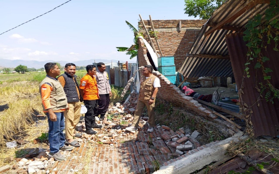
A devastating magnitude 7.7 earthquake struck Indonesia's Flores Island in the East Nusa Tenggara province in the early hours of Saturday, triggering a massive humanitarian response as approximately 2,000 residents either fled their homes or were formally evacuated by disaster management officials. The initial tremor, which struck at 4:58 am local time with its epicentre located roughly 30 kilometres from Mbay in the ocean at a depth of 15 kilometres, was powerful enough to generate a tsunami alert that sent residents rushing to higher ground. Though the Meteorology, Climatology and Geophysics Agency (BMKG) lifted the tsunami warning by 7:31 am after observations indicated sea levels had stabilised, the psychological impact of the warning combined with the strength of the initial quake drove widespread civilian displacement across multiple districts and municipalities in the region.
The death toll from the earthquake and subsequent aftershocks had climbed to at least 20 by Saturday morning, according to the Maumere Search and Rescue Office, with a further six individuals sustaining injuries and two others remaining trapped beneath rubble. These figures underscore the immediate human cost of the disaster and highlight the ongoing search and rescue operations being conducted across multiple affected communities. The casualty count serves as a sobering reminder of Indonesia's vulnerability to seismic activity along the Pacific Ring of Fire, a geological reality that residents of the archipelago must continuously contend with.
Berton Suar Pelita Panjaitan, the acting chief of the National Disaster Management Agency's (BNPB) Disaster Data, Information and Communication Centre, reported that structural damage assessments were still ongoing and far from complete. According to preliminary surveys conducted on the ground, 54 residential dwellings suffered severe structural damage while nine sustained moderate harm and eleven experienced minor damage. Beyond residential structures, the earthquake's impact extended to critical infrastructure including five health facilities, a single educational institution, three religious buildings, a warehouse operated by Bulog the state logistics body, and six government administrative offices. Panjaitan emphasised that verification teams were actively working across all affected zones to compile comprehensive damage inventories and validate casualty information, with the full extent of destruction likely to emerge over subsequent days.
Manggarai district, located in the central portion of Flores Island, emerged as an epicentre of destruction with 29 severely damaged houses, nine moderately impacted residences, and nine properties with minor damage. The adjacent East Manggarai district reported similarly severe destruction with 23 houses extensively damaged. These two administrative divisions appear to have borne the brunt of the seismic energy released by the main earthquake, though damage patterns across the broader region suggest the tremor affected communities across a far wider geographical footprint than initial reports indicated. The concentration of destruction in these particular districts points to variations in ground conditions, building construction standards, and proximity to the epicentre that helped determine which areas suffered the most catastrophic outcomes.
What distinguished Saturday's earthquake from many other seismic events in the region was the extraordinary frequency of aftershocks that continued to rattle Flores throughout the morning hours. The Meteorology, Climatology and Geophysics Agency recorded 111 distinct aftershocks in the hours following the main earthquake, a frequency that would have kept residents in a state of heightened alarm and made recovery efforts significantly more challenging and dangerous. Aftershocks of such magnitude and frequency prevent the stabilisation of partially damaged structures, render rescue operations more hazardous, and often trigger secondary collapses that claim additional lives. For residents traumatised by the initial earthquake and uncertain about the structural integrity of their dwellings, the continuous seismic activity would have extended the period of acute psychological distress and necessitated prolonged displacement from their homes.
The immediate response to the disaster involved coordination across multiple layers of Indonesia's disaster management system, with the BNPB working alongside regional disaster management agencies, military personnel, police forces, and local government administrations. Teams deployed to affected areas worked systematically to identify survivors, extract those trapped beneath debris, document damage patterns, and provide initial humanitarian assistance to displaced populations. This coordinated approach reflects established protocols developed over years of experience managing the country's frequent natural disasters, yet each earthquake presents unique logistical challenges that test the capacity of these response systems. The BNPB statement emphasised that assessment and verification operations would continue over subsequent days, suggesting authorities anticipated significant additional work in understanding the earthquake's full impact.
An often-overlooked dimension of major earthquakes involves their impact on communication infrastructure, and Saturday's event in Flores was no exception. As of 7:00 am Saturday morning, the Ministry of Communication and Digital Affairs had identified disruptions affecting 200 base transceiver station (BTS) sites across 10 different districts and cities throughout East Nusa Tenggara province. According to Wayan Toni Supriyanto, the ministry's Digital Infrastructure director-general, these affected sites represented 16.35 per cent of all BTS installations in the impacted regions. The communication blackouts hampered emergency response efforts, prevented residents from contacting family members, and limited the capacity of authorities to disseminate critical safety information to the public. The ministry worked urgently with mobile network operators to restore service to these facilities, recognising that functional telecommunications networks represent a critical element of comprehensive disaster response and community recovery.
For Malaysia and other Southeast Asian nations, the Flores earthquake serves as a sobering reminder of the region's persistent seismic vulnerability and the need for continued investment in earthquake preparedness, building code enforcement, and disaster response capability. Indonesia's position along the Pacific Ring of Fire means large earthquakes represent an enduring threat, and the nation's experience managing this particular disaster offers valuable lessons for regional neighbours regarding evacuation protocols, communication during emergencies, and the particular challenges posed by high-frequency aftershock sequences. The scale of displacement—with 2,000 residents requiring evacuation—demonstrates how earthquakes of this magnitude can rapidly generate humanitarian crises requiring sustained response capacity.
The geological forces that generated Saturday's magnitude 7.7 earthquake remain active beneath the Indonesian archipelago, and authorities across the region must treat this event not as an anomaly but as a manifestation of deeper tectonic processes. The relatively shallow depth of the epicentre at 15 kilometres contributed to the surface damage and widespread impact, whereas deeper earthquakes sometimes dissipate their energy before reaching populated areas. Understanding how local geological conditions interact with earthquake energy transmission helps communities better prepare for future events through improved building designs and emergency planning. As displaced residents in Flores awaited updates on when they could safely return to their homes and begin assessing the full scope of property losses, Indonesian disaster management authorities faced the daunting prospect of simultaneously managing ongoing aftershock sequences, scaling up humanitarian assistance, and conducting systematic damage inventories to guide the long-term recovery and reconstruction process.

