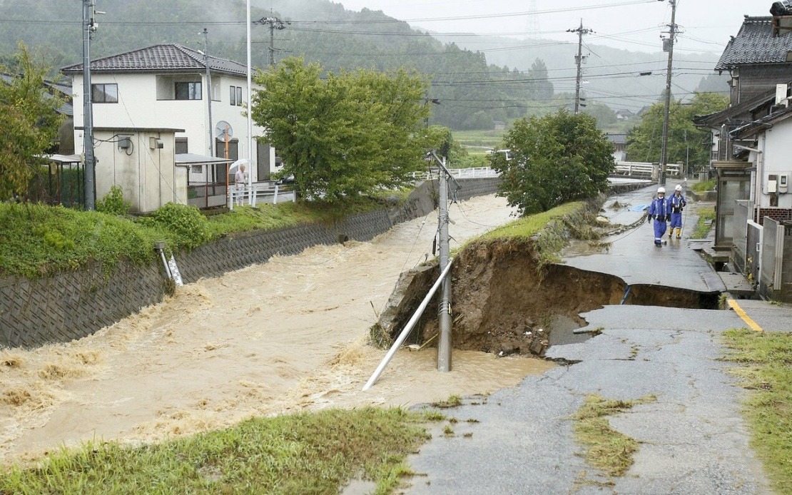
Central Japan endured a severe weather event Thursday as torrential rainfall swept across Ishikawa and Toyama prefectures, triggering the nation's most critical alert status for atmospheric hazards. The Japan Meteorological Agency's Level 5 warning—indicating disaster has either already struck or is virtually certain—reflected the genuine peril residents confronted as water systems overflowed and earth movements destabilised hillsides throughout affected municipalities.
The emergency protocols extended across five municipalities facing the severest risk. Himi in Toyama Prefecture, along with Hakui, Shika, Hodatsushimizu, and Nakanoto in neighbouring Ishikawa Prefecture, became focal points for evacuation guidance. Collectively, approximately 180,000 people received instructions to prioritise immediate safety measures, either relocating to secure locations or preparing refuge within their homes as conditions deteriorated.
Rainfall intensity reached alarming proportions in the twelve hours concluding at 7:20 am local time. Himi and Hakui each recorded over 300 millimetres, surpassing previous records established at those recording stations. Hodatsushimizu similarly exceeded historical benchmarks, accumulating more than 200 millimetres. Such concentrated precipitation within brief timeframes overwhelms drainage infrastructure and saturates soil, creating conditions where flooding becomes inevitable and slope failures imminent.
On-ground accounts underscored the crisis's tangible nature. A firefighter in his fifties from Himi recounted to Kyodo News how nearby river systems had breached their banks, with multiple vehicles now fully submerged in floodwaters. The image of abandoned automobiles surrounded by moving water represents not merely property damage but signifies stranded individuals requiring emergency assistance and the breakdown of normal transportation systems.
The atmospheric setup generating such destructive rainfall involved a confluence of meteorological factors. A frontal boundary extending from the Sea of Japan eastward through northern and eastern sections of the archipelago was expected to shift southward through Friday, bringing additional precipitation. Simultaneously, a cold-air mass and a pressure trough destabilised atmospheric conditions, creating an environment conducive to sustained heavy precipitation and embedded thunderstorms.
Projections for the following 24 hours indicated continued precipitation threats. Hokuriku region faced forecasts of up to 200 millimetres, while the Kanto-Koshin and Tokai zones anticipated up to 150 millimetres. Niigata Prefecture, immediately neighbouring the initial impact zone, also experienced significant rainfall, expanding the affected territory and multiplying the number of communities requiring vigilance.
For Malaysian observers accustomed to monsoonal weather patterns and frequent tropical downpours, Japan's response protocol reveals important contrasts in disaster management approaches. While Southeast Asia regularly experiences intense rainfall, Japan's sophisticated early warning systems and mandatory evacuation frameworks reflect densely populated island conditions where preparedness infrastructure becomes critical. The Level 5 designation represents the culmination of a tiered response system designed to communicate escalating danger progressively.
Recent precedent underscored the potential severity. Just weeks earlier in August, Level 5 warnings activated in certain Chiba Prefecture municipalities neighbouring Tokyo, resulting in catastrophic consequences. That event claimed thirteen lives and left approximately 2,500 vehicles abandoned simultaneously across prefecture roads, demonstrating how meteorological disasters can cascade into multiple crises—loss of life, mass displacement, transportation paralysis, and economic disruption.
As of reporting time, Ishikawa prefectural authorities had documented no confirmed fatalities, suggesting that advance warnings and evacuation messaging may have successfully reduced human casualties. However, infrastructure damage, property loss, and the psychological toll of forced displacement represent significant ongoing consequences extending well beyond the immediate weather event.
The geographic concentration of this disaster in Japan's central belt reflects how orographic and atmospheric patterns can create localized zones of extreme vulnerability. Mountainous terrain common throughout the Hokuriku and surrounding regions naturally channels moisture-laden air masses, intensifying precipitation. The same topography that creates spectacular landscapes also generates steep slopes prone to instability when saturated.
For regional context, such weather events increasingly dominate East Asian meteorology as climate patterns shift. Japan's experience Thursday mirrors challenges confronting other densely populated nations across Southeast Asia and the broader region, where intense precipitation events have become more frequent and unpredictable. The Japanese response—combining real-time monitoring, automated alert dissemination, and coordinated evacuation—establishes benchmarks that neighbouring countries continue studying and adapting to local conditions.
Staying informed about such unfolding situations remains essential, particularly for regional travellers and those with connections to affected prefectures. Japanese authorities maintained ongoing monitoring as weather systems evolved, with continued updates expected as Friday's forecast period progressed. The interplay between technological capacity and human response during such events ultimately determines whether warnings translate into saved lives.

